
‘Increasingly unsettled’ weather is forecast later in the week, the Met Office says
Heavy rain and strong winds that could bring “difficult driving conditions and the risk of flooding in a few places” has led to two weather warnings being issued for Hull and East Yorkshire. The Met Office is forecasting the stormy weather due to an area of low pressure moving in late on Wednesday.
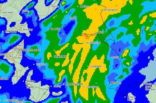
The rain warning, which will be in place for 21 hours from midnight on Thursday, states: “A complex area of low pressure over the mid-Atlantic early this week is expected to move towards the UK whilst deepening, but confidence in the details of its track and intensity as it crosses the UK remains fairly low.
“Despite these uncertainties, there is at least a medium likelihood that an extensive, and in places heavy swathe of rain will move into southwestern Britain during Wednesday evening and spread quickly northeast, with totals by early Thursday morning of widely 20-30mm, and for some places 30-50mm.”
Meanwhile, a wind warning will be in force between 9am on Thursday and midnight on Friday. It says: “Winds will pick up in association with the low, and as it clears from the east coast, very strong northwesterly winds are likely to develop.
“Gusts of wind of 45-55 mph can be expected widely, with 65 mph possible near coasts. There is a smaller chance, should the low be deeper, that wind gusts of 65-75 mph may develop for a time very locally, this most likely late morning and into the afternoon.”
Met Office Deputy Chief Meteorologist, Dan Harris, said: “Low pressure moving across the south of the UK on Thursday will bring both a spell of heavy rain and areas of strong winds. The rain is expected to arrive from the southwest during Wednesday evening, before spreading northeast to many parts of England and Wales during Thursday, leading to difficult driving conditions and the risk of flooding in a few places.
“At the same time, winds are expected to pick up along south coastal areas in particular. However, it is not until Thursday morning that significantly strong northwesterly winds will first begin to affect parts of the west with gusts of 45 to 55 mph, locally 65mph around coasts expected. A little later, northerly winds are expected to develop more widely across eastern areas, most likely of similar strength, but there is a small chance of gusts in excess of 70mph should the low pressure system end up being at the stronger end of expectations.
“It is worth noting that there is a greater than usual uncertainty surrounding the track and intensity of this low-pressure system, so the public should stay up to date with the latest forecasts and warnings as the situation evolves, with adjustments to the forecasts likely at short notice.”
During the warning period, there is a chance of impacts including delays to transport, damage to buildings, power cuts, and dangers relating to flying debris.
Temperatures will dip later in the week too with daily highs of 12C on Thursday, falling to between 10 and 11C between Friday and Sunday. It is expected to be chilly overnight too, particularly over the weekend, when lows of around 4C are forecast.