
There could be ‘substantial disruption’ in the worst affected rural areas, the Met Office says
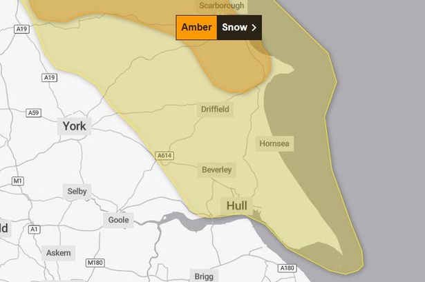
Snow and ice warnings have been extended in East Yorkshire, including a higher ‘amber’ level alert for some parts of our region. The Met Office says “frequent wintry showers will feed inland from the North Sea” with a risk of “significant snow accumulations” in parts of the Yorkshire Wolds.
The amber-level weather warning, which will be in force for 18 hours between 3am and 9pm on Thursday, covers north-easterly parts of the East Riding including areas to the north and west of Bridlington. The alert area also extends into North Yorkshire, including Scarborough and the Moors.
In these places, the Met Office says travel delays on roads are “likely” with a risk of power cuts and delays to train and bus services. In its warning, the forecaster says: “By the end of Thursday, as much as 15-25cm may have accumulated on hills above 100m elevation, which is likely to cause substantial disruption.
“Gusty winds, giving occasional blizzard conditions, and perhaps a few lightning strikes, may accompany some of the showers, posing as additional hazards.”
Meanwhile, a yellow-level snow and ice warning is currently in place covering Hull and the majority of the East Riding. It began at midnight today and will remain in force until 11.59pm on Thursday.
For these areas, the Met Office says: “Wintry showers feeding inland from the North Sea through Wednesday and Thursday may give some snow accumulations in places, especially farther inland away from the immediate windward coast. Whilst there will be a lot of regional variation, with some places seeing little or no lying snow, where showers are most frequent accumulations of 2-5cm are possible.”
The forecaster adds that, where showers persist or any snowfall thaws, sub-zero temperatures overnight will bring a risk of ice forming.
In Hull, daytime highs of just 4 or 5C are expected until the weekend with overnight lows falling below zero at times. Due to the gusty winds it will seem even colder too with ‘feel like’ temperatures of between -1C and -5C throughout the next couple of days.
Met Office Chief Forecaster Neil Armstrong said: “Cold Arctic air from the north is firmly in charge of the UK’s weather, bringing the first notable cold snap of this autumn and giving an early taste of winter weather. As a result, winter hazards are likely through the next few days, with snow and ice a particular hazard, and the coldest conditions likely on Wednesday and Thursday.
“Wintry showers will affect areas exposed to the brisk northerly wind, in particular Northern Ireland, southwest Wales, southwest England, northeast England and across the northern half of Scotland. Whilst not all places will see lying snow, where showers are most frequent accumulations of 2-5cm will be possible.
“On higher ground in Scotland, 15-20cm could accumulate, and potentially as much as 15-25cm over the North York Moors and Yorkshire Wolds.”