
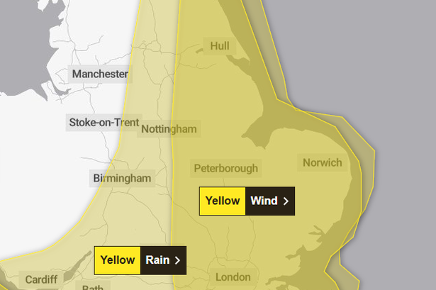
The warnings are for strong winds and heavy rain
Two yellow weather warnings for wind and rain affecting the Hull and East Yorkshire region have been updated. The Met Office has now issued an earlier start time for the warnings to be in force and for stronger winds and heavier falls of rain than first forecast.
The Met Office said: “Strong winds may cause travel disruption and some damage across eastern England during Thursday.” The start time has been brought forward to 0300 and the wind warning currently expires at 2359, with the update including “wind strengths slightly increased”.
The storm is expected to move from the English Channel to the North Sea during Thursday. As it moves across the southeast of England, stronger northeast to northwest winds are likely to develop, with gusts of 50-60mph “probable” quite widely, with 65-70mph possible near coasts.
“There is a smaller chance, should Storm Benjamin be at the stronger end of expectations, that wind gusts in excess of 70mph could develop for a time very locally, this most likely late morning and into the afternoon,” the report said. “There remains considerable uncertainty over the precise track and intensity of Storm Benjamin, which will significantly impact the details at your location.
“Near to its centre, a marked lull in winds is likely even during the period of this warning, with a sharp increase then occurring as the centre moves away northeast.” The warning covers Hull and the East Riding, North Lincolnshire and North East Lincolnshire.
There is also the risk of heavy rain for southern and eastern parts of Britain with a yellow warning for rain. The Met Office said: “Storm Benjamin is expected to cross the south of the UK later Wednesday and early Thursday; confidence in its track has improved compared to yesterday [Tuesday] but still remains lower than usual for this type of weather system, which leads to continued uncertainty over the corridor of highest rainfall totals.
“That said, an extensive and in places heavy swathe of rain will move into southwestern Britain later Wednesday and spread quickly northeast, with totals by early Thursday morning of widely 20-30mm, and for some places 30-50mm. There is a chance a few places could exceed this, most likely over North Devon and Cornwall and also within a broad area encompassing Lincolnshire, Humberside, East Anglia and East Midlands.”