
It is the first named storm since January
The northern half of the UK is set to be hit by strong winds and heavy rain on Monday, as Storm Floris is named by the Met Office. A yellow-level weather warning for wind has been issued though only more westerly parts of East Yorkshire are currently included in the warning area.
The sixth named storm this season – which begins each September – and the first since Storm Éowyn in January, will travel right across northern regions. Current forecasts paint a picture of the strongest and most disruptive winds on the southern and western edges of the area of low pressure, developing in the Atlantic, where it is set to be picked up by an active jet stream.
“This unseasonably disruptive system will bring strong winds and heavy rainfall across the northern half of the UK on Monday and early Tuesday,” a spokesperson for the Met Office said. The yellow wind warning – issued on Friday, August 1 – covers a swathe of the northern half of the UK, from Northern Ireland, north Wales, northern England, and the whole of Scotland where the strongest winds are more likely to be recorded.
The warning will be in force from 6am on Monday, August 4 until 6am on Tuesday, August 5. Matthew Lehnert, a Met Office chief meteorologist, said: “Across the warning area, many inland areas are likely to see gusts of 40-50mph, with 60-70mph more likely at higher elevations and around exposed coasts in Scotland.
“There is a small chance that some locations here could even record gusts of 85mph.” As Storm Floris tracks across the northern half of the UK, winds will first begin to ease in the west on late Monday but remaining very strong until early Tuesday in the east of the warning area. Heavy rain may contribute to disruption in places.
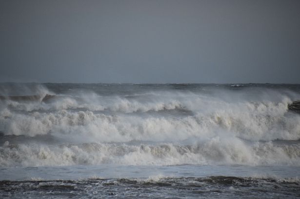
The yellow warning for wind means there could be some damage to buildings, such as tiles blown from roofs. Injuries and danger to life from flying debris are possible. Power cuts may occur, with the potential to affect other services, such as mobile phone coverage. Injuries and danger to life could occur from large waves and beach material being thrown onto sea fronts, coastal roads and properties.
Some roads and bridges may close. Road, rail, air and ferry services may be affected, with longer journey times and cancellations possible.
Though most of East Yorkshire is not included in the warning area, a blustery period is still expected across our region on Monday and Tuesday. Gusts are currently expected to top 40mph with showers possible around the area.
Although named storms are more frequent in late autumn and winter, it is not uncommon for named storms to occur in summer. Ahead of Storm Floris, the weekend will bring a mix of sunshine and showers.
You can find the latest forecast on the Met Office website.